Provide solutions to build and manage fire protection maps, solutions to support fire management, fire protection equipment on the FPF map, localize fire places and give fire warnings.
Determine the specific fire location quickly and accurately thanks to the positioning feature.
Helping the FPF center quickly make a plan to rescue and rescue based on the general information of the fire sent from the system.
The deployment to the fire location will be shortened by the feature to find the shortest route in the map.
Support fire fighting in a timely and rapid manner, minimizing significant damage to property and human life based on the feature of setting up the map of the rescue area and showing the point of protection in the fire area.
Contribute to increasing the efficiency of rapid fire treatment thanks to the ability to quickly search fire water sources according to the radius around the fire area.
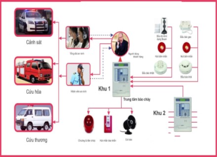
Managing and monitoring the status of works, manpower and means of fire protection to support optimal force mobilization through management and monitoring applications.
.png)
Store profile information, minutes, personnel information, number of FPF staff. Store information of locations containing fire protection equipment. Store map data layer on fire protection.
Show zoned fire areas on the map.
Look up fire prevention data, look up the address of the fire area address on the map.
Display of fire protection equipment, status of fire protection equipment.
Show rescuing capacity, protection points in the fire zone.
Send operational warrants to relevant units.
Statistics report the number of fires occurring by year, month and region.
.png)